|
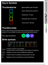
 Key
features Key
features
 Displays strikes, thundery areas and thunderstorms
updating every minute. Displays strikes, thundery areas and thunderstorms
updating every minute.
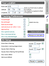
Uses
your post code to set your latitude / longitude or can be set manually
so that data is customised to your location.
Audible
and/or visual alerts can be set for 'Local' and/or 'Severe' storm
targets.
Tracking
can be set to Closest, Newest, Most Severe, Most recent strikes
or Approaching storms, or the system will track a storm by its ID
no.
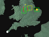
Clickable, interactive map to allow individual targets
to be isolated and tracked easily.
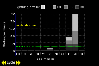
Auto-scale graph of strike type and quantity over time
for each target.
Precipitation overlay (courtesy ©Meteox).
Plays
a storm simulation in real-time based on real-time strike data.
 Stand-by mode for alerts and warnings
Storm area navigation data
- Post Code, Town and County of close populated area and full printable
map & route planner from your location to storm coordinates.
|